
Northing/Easting Points
- Northing/Easting Points Overview
- Northing/Easting Point Variations
- Northing/Easting Points are Now MLeaders!
- Scaling
- World Coordinate System (WCS), User Coordinate System (UCS), and Northing/Easting Points
- Northing/Easting Point Schedule
- Use Different Units for Northing/Easting Points
- Troubleshooting
Northing/Easting Points are designed to mark known survey points in your site plan. You can also place a Northing/Easting Point Schedule that lists all Northing/Easting Points in your drawing.
Northing/Easting Points Overview
Place a Northing/Easting Point in a drawing:

F/X Site ribbon, Northing/Easting Point flyout

F/X Site menu, Northing/Easting Point flyout
or type FX_PlaceNorthingEasting Point in the Command line
You can also place Northing/Easting Points by opening the Discipline Graphics tool and selecting the Callouts category of graphics. For more information, see Northing/Easting Point Variations below.
Once you select the Northing/Easting Point tool, you'll place a Northing/Easting Point each time you click in your drawing.

- You can turn on OSNAP (type OSNAP in the Command line) to snap the points to something like the end of a line.
- The Northing/Easting Point will be measured from the 0,0 insertion point. Therefore, that location needs to be a known survey point.
- If you change the orientation of the site with a User Coordinate System (UCS), the Northing/Easting Point will still measure to the 0,0 point of the World Coordinate System (WCS). Only the orientation of the number and layout will reflect the UCS orientation. See WCS, UCS, and Northing Easting Points below.
Northing/Easting Point Variations
Our Discipline Graphics tool includes a library called Callouts. Within this library are four options for the Northing/Easting Points.

These options will place the distance in either Northing-Easting, or just Northing or Easting, from the insertion point 0,0 of the drawing to the location selected. The 0,0 insertion point of the CAD file should be a known survey point or benchmark that can be measured from in the field.
The Northing/Easting callouts use the font CALLOUT LIGHT. You are welcome to edit this font to your preference using the Text Manager.
After using the Grading Tools to place some Northing/Easting points, you can display those points and edit the information about them from within the Grading Manager.
The Grading Manager is now a docked palette. Want to undock this palette? See our documentation on docking and undocking palettes such as the Grading, Irrigation, and Plant managers.


If you want, you can edit a description for one or more points by selecting the point and then clicking Edit.
Enter a description for the selected point in the Point Remarks dialog box.

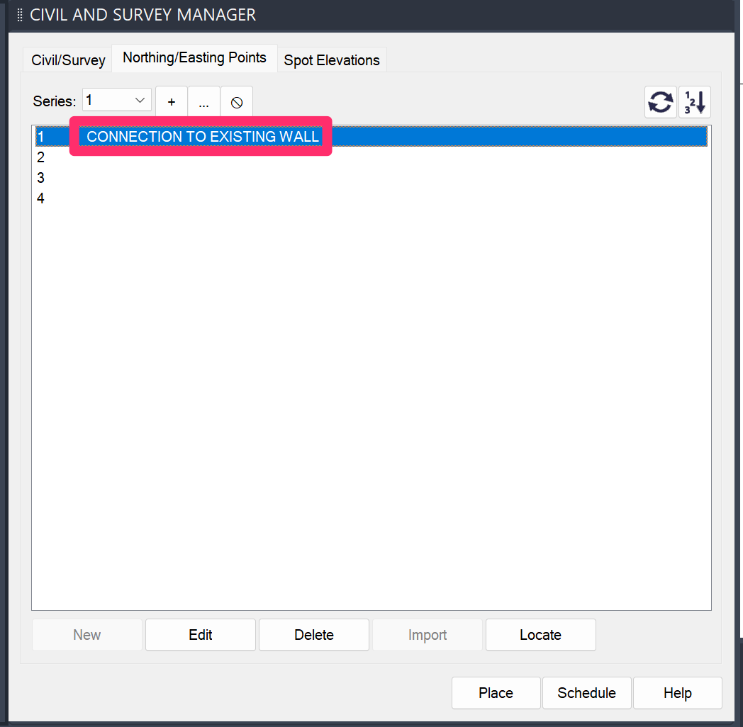
The description will be added to the point in the list.
Northing/Easting Points are Now MLeaders!
We've updated Northing/Easting Points, Northing Points, and Easting Points to be multileaders (MLeaders), making them much easier to move around. We've also added a background mask to all these callouts, making them easier to read on a hatched or colored background.
How to Match the MLeader Callouts with Existing Northing/Easting, Northing, and Easting Callouts
Note that when you place these MLeader callouts, they will not match existing callouts of the same type. Here are two possible solutions to this minor issue:
Option 1:
We've created "Legacy" commands that will allow you to fire the old style of each of these callouts as needed in your existing drawings:
- fx_NorthingEastingCalloutLegacy (Legacy Northing/Easting Callouts)
- fx_NorthingCalloutLegacy (Legacy Northing Callouts)
- fx_EastingCalloutLegacy (Legacy Easting Callouts)
Option 2:
The updated MLeader style is created based upon our Callout Light Text Style. The Land F/X Preferences have Callout Light set to 8-point text size, while the Legacy northing/easting blocks are set for 10-point text size. To make the new ones match, you can simply:
1. Delete any of the new MLeader callouts you've placed.
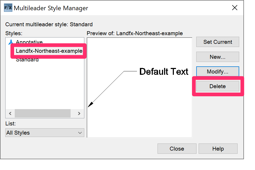
2. Type MLEADERSTYLE in the Command line and press Enter to open the AutoCAD Multileader Style Manager.
Delete any MLeader styles whose names start with Landfx-Northeast-.
3. Open our General Preferences screen, edit the Callout Light Text Style, and set it to 10-point size.

New Northing/Easting, Northing, and Easting callouts placed in your drawing will now match the older versions.
Scaling
Northing/Easting Points come in relative to the scale you've set in your drawing. If that scale changes, they don't rescale automatically. However, you can scale Northing/Easting Points manually in the Properties palette.
To open the Properties palette, type Properties in the Command line and press Enter.
Select any Northing/Easting Point (or all Northing/Easting Points in your drawing).
To rescale them, enter new Scale X and Scale Y values in the Properties panel (as pictured to the right).

World Coordinate System (WCS), User Coordinate System (UCS), and Northing/Easting Points
Northing/Easting Points recognize the World Coordinate System (WCS) value. If you need them to recognize the User Coordinate System (UCS) value, you'll need to change the USERR3 setting in AutoCAD.
Type USERR3 in the Command line. When prompted to set a value, you can:
- Type 1 to use UCS values, or
- Type 0 to use WCS values
Northing/Easting Point Schedule
You can create and place a Northing/Easting Point Schedule from the Grading Manager. Open the Grading Manager:

F/X Site ribbon, Grading flyout

F/X Site menu, Grading option

Graphics toolbar

GraphicsRefNotes toolbar
or by typing FX_Grading_Manager in the Command line
In the Grading Manager, select the Northing/Easting Points option.
Click Schedule to place a Northing/Easting schedule.


Select a destination for the schedule:
- Drawing: Place the schedule directly in your drawing.
- Table: Place the schedule in your drawing in table format.
- Spreadsheet: Send the schedule to a spreadsheet program, such as MS Excel, for further editing.
Click OK when finished.
If you select Drawing or Table, the Command line will prompt: Upper Left Corner.
Click to place your Northing/Easting Point Schedule. The schedule will include columns for a Description (if provided), Northing coordinate, and Easting coordinate for each Northing/Easting point.
Here's an example of a Northing/Easting Point Schedule:

Use Different Units for Northing/Easting Points
You might want your Northing/Easting Points to use units that differ from the units you're using in your drawing.
For example, you might be drafting in Architectural Inches but want your Northing/Easting Points to display as feet. Or you're drafting in Decimal Feet but want your Northing/Easting Points to display as inches.
For instructions, see our article on using different dimensions or units for Northing/Easting Points.
Troubleshooting
Contact
- Land F/X


Our software tailors AutoCAD® to the needs of landscape architects, irrigation designers, and other professionals. We automate your most tedious tasks and ensure accuracy, giving you more time to design.